|
|||||
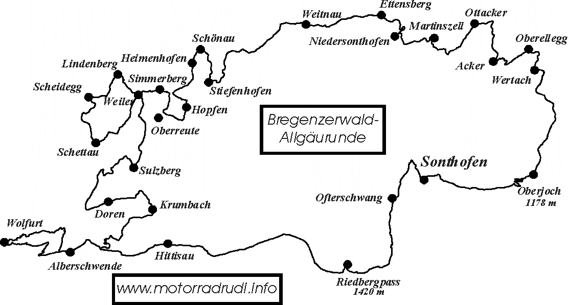
Bregenzerwald - AllgaeutourTour description/route characteristicsThe tour leads over many small/small roads, but there are also longer sections with wide, well-developed routes - so there is something for everyone! The landscape is very varied and offers on the one hand on the section between Alberschwende and Wolfurt very nice views of Lake Constance and the Rhine Valley and on the other hand on the German side very nice views of the Allgäu. First of all turn left from Sonthofen station and continue to the traffic lights. Turn left there. At the next roundabout go straight on and continue to the next traffic light. Turn right here towards Blaichach. Shortly after the bridge over the Iller (in Bihlerdorf) turn left and immediately after leaving the village turn right towards Hüttenberg. Via Bettenried - turn right - to Ofterschwang and on to Bolsterlang. Here turn right (signposting "Dorflift"). Via Sonderdorf you reach the road to Riedbergpass (1420 m). Follow the road via Balderschwang to Hittisau. Turn left here and continue via Lingenau to Alberschwende-Müselbach. Here turn right to Alberschwende. In Alberschwende at the junction of the B200 (left to Dornbirn) first straight ahead. 900 m after the junction turn right onto a narrow and partly unclear road. This road offers beautiful views of Lake Constance and the Rhine Valley. After 2 km turn diagonally left over the crossing. After another 2.5 km turn right. Then - also 2.5 km further on - keep right again. After 3.5 km - in Wolfurt - turn left onto Wingertgasse. Turn left at the right-of-way sign and after approx. 100 m turn left again into Rickenbachstraße - from here it is partly steep uphill again. Turn left again at the next junction and continue uphill. At the turn-off to Alberschwende first turn left. Shortly afterwards (approx. 300 m) the road turns sharply right. After 2.5 km keep right at a fork in the road and follow the road further (2 km) until you reach the main road. Turn left there and drive via Alberschwende back to Müselbach. Turn left there and after the bend immediately right again. It goes under the bend. After just under 5 km - in Langenegg - turn left to Krumbach. There turn left and after 400 m left again towards Doren. Beyond Doren (from the turn-off in Krumbach) 11.5 km further on the well developed main road. Then turn right towards Sulzberg. Here you have a really nice view from the terrace - but the adjacent gastronomy pays princely for this view, so I don't stop here anymore! I continue over the German/Austrian border towards Oberreute. But before that I turn left to Weiler. (Here you have the possibility to have a good and cheap coffee/cake at the bakery Wucherer), turn left and after 100 m turn left again into the church square. There (on the right) you can already see the yellow signposts indicating the further direction. The road is wide at first, but becomes narrower later. Then it goes steeply downhill. Then keep right and after a total of 5.5 km (since the church square in Weiler) you will come back to the main road. Turn left there and after 700 m turn diagonally right again onto a small side street. This leads after 800 m near Scheffau to Scheidegg (turn right). Follow this road for 3.5 km and then turn right to Rorgenmoos. After 1.2 kn keep left and another 400 m further on also left. After another km in Scheidegg turn right to Börserscheidegg. At the end of the village turn left towards Ried. (At the end of Ried the Gasthof Schönblick offers a good place to stop for a bite to eat). After 1.5 km you reach the B 308, turn right and after 200 m left again. In Lindenberg turn right onto Ahornweg and 400 m further on turn right onto Buchenweg. 200 m further on, turn right again and a small, partly steep road leads to Weiler again. Keep left and turn left at the right-of-way sign. Then - after 600 m - turn right to Simmerberg. Follow the main road through the village and after the end of the village turn right towards Oberreute. After 2 km (BEFORE the underpass) turn sharp left and then left again on the B 308. Follow the main road for 1.5 km and then turn left towards Hopfen. After 2.5 km you will reach the route from Simmerberg to Genhofen again. There turn left and after 500 m turn right towards Stiefenhofen. After 2.5 km turn left again towards Heimenhofen and Schönau. In Schönau then turn right to Harbatzhofen. There turn right towards Oberstaufen. After 2 km in Stiefenhofen turn sharp left towards Oberthalhofen. Keep straight ahead and then turn left. Via Jungensberg you get back to the main line. There turn right and via Ebratshofen and Sibratshofen the route continues to Seltmans. Turn right there. Follow the route - beyond Weitnau - for 4 km and then turn right towards Eisenbolz and later Ettensberg. Via Ettensberg the tour then leads to Niedersonthofen. Turn left there and after 200 m turn right again. After 1 km turn left towards Oberdorf. Keep left there - over the B 19 - and then turn right to Martinszell. Then follow the road for 3 km. Then turn left to wolfis. There turn right via Bechtris to Ruchis. Then - again on the main line - keep right until Ottacker. There turn right towards Moosbach. At Albis then straight ahead on the main road. Follow this road until Rieder. There turn left! Via Acker (turning left there) the road continues (partly) steeply uphill. At the end of the road at the right-of-way sign turn left and via Oberellegg to Wertach. Here first turn left and then immediately right again (behind the church). Then at the junction to the main road drive straight on and turn right at the traffic lights (B 310). Then follow the main road to Oberjoch and continue over the Jochpass road to Hindelang and back to Sonthofen. Route length 240 km Tour files for download |
|||||


